|
Blackstone River Watershed Association
|
|
|
BRWA NEWS
|
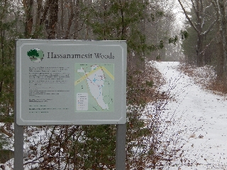
Winter Hike
Entrance to Hassanamesit Woods, a 200-acre
historic and
natural conservation gem in Grafton.
Photo: Susan Thomas
|
It's almost time for you to join us for our
annual winter hike on Sunday, January 25th from 1:00 - 3:00 pm at the
Grafton Land Trust's Hassanamesit Woods. You'll be amazed at the
fascinating history and science that you'll learn along the way!
- Have you heard that UMass has been conducting detailed archeological surveys here since 2003?
- Did you know that over 60 species of birds have been documented on the property?
- Do you want to hear about a local stone quarry site used long ago to produce lithic tools?
- Did you realize a power line corridor could actually insulate natural communities from invasive plants?
- Would you like to view wells, cisterns, and boundary walls dating from the Nipmuc residents of the1700s?
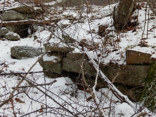
Remains of old dry bridge at
Ellis-Salisbury Farmstead in Hassanamesit Woods.
Photo: Susan Thomas
|
This is just a sample of the intriguing conversations we'll have
during the hike! Wear appropriate footwear for the uneven ground,
which may be snow covered or muddy depending on the weather.
Following the hike, we will enjoy warm drinks and refreshments.
Participants should meet at the gated end of Salisbury Street, which is
located off of Keith Hill Rd. in Grafton near Rt. 122.
Directions are available at:
http://www.graftonland.org/openspaces.properties.details.php.
For more information, or to RSVP, please e-mail
events@thebrwa.org.
See you there!
top
|
On Board with the BRWA
The BRWA is thrilled to have several talented, passionate people join
our board! Please consider coming to one of our monthly meetings
(see Calendar) to meet these wonderful stewards
of the Blackstone!
- Pieter de Jong has worked for 35
years as an environmental planner for local, state and federal agencies
and consulting firms. He currently provides consultant services in
disaster management, sustainability and climate change adaptation. He
holds degrees in biology, environmental studies and regional planning
from U. Penn. Since moving here from MD, he has been exploring the
beauty and historic landscape of Blackstone River watershed by trail
and kayak. Those experiences lead to his desire to volunteer for the
BRWA, BRC and NPS BRVNHC.
- Tara Neal worked for over 10 years
as an application developer and project manager. She holds degrees in
Information Technology and Physics from Capella University and Wheaton
College. She loves the beauty of the waterways in the Blackstone River
Watershed and actively contributes to their protection and improvement.
She is a BRC water quality monitor and helps with BRWA river clean-ups.
She shares her love of the outdoors with her children on nature hikes
when not exploring backyard wonders.
- Michelle Walsh has been affiliated
with the BRWA since 2006 as a volunteer water quality monitor, a Board
member, and as an Outreach Coordinator, where she oversaw media
relations, served as a liason for municipalities, facilitated shoreline
surveys in partnership with Mass Riverways and Save the Bay, and
coordinated other BRWA outreach programs. She has been involved with
invasive species removal and watershed models within the classroom.
Michelle has a degree in Business Administration.
top
|
|
CALENDAR OF EVENTS
|
According to sources, January is a smorgasbord of
culinary celebrations including National Cream Puff Day, National Fig
Newton Day, National Croissant Day, and my personal favorite, National
Pie Day. All this celebrating will certainly require some calorie-burning
exercise. The solution? Join us for our annual winter hike on Sunday the
25th!
|
|
1/21
|
Cost Effective Green Infrastructure in the Blackstone River Watershed.
8:00 -9:00 a.m. Union Station, Worcester. Mass
Audubon, the Central Mass Regional Planning Commission,
Horsley Witten Group, Inc., and the BRC. This project will assist
municipalities, businesses, and residents with practical methods to
minimize costs of development and local infrastructure maintenance, reduce
flooding, improve water quality, and protect and restore natural features
critical to quality of life and property values.
RSVP: netshapingthefuture@massaudubon.org.
or 781-259-2146.
|
|
1/21
|
Blackstone River Watershed Council Monthly Meeting.
6:30pm - 8:30pm. Lincoln RI.
info
|
|
1/22
|
BRWA Board Meeting.
6:45 p.m. to 8:00 p.m. 271 Oak St., Uxbridge.
info
|
|
1/25
|
BRWA Annual Winter Hike.
1 - 3p.m. Hassanamesit Woods, Grafton.
Park at end of Salisbury Street by gated entrance to trails.
Directions
See above for more information.
|
|
1/27, 29
|
Basic Freshwater Fly Tying Course.
7:00 9:00 P.M. Fisheries and Wildlife Field
Headquarters, Westborough. Charlton Conservation Dept. & Mass Wildlife.
Two free courses for beginners. Pre-registration is mandatory.
For info, contact Jim Lagacy 508-389-6309 or email
jim.lagacy@state.ma.us.
|
|
2/4
|
Wetland Shrubs in Winter.
10:00 a.m. - 2:00 p.m. New England Wild Flower
Society. Garden in the Woods, Framingham.
info
|
|
2/18
|
Blackstone River Watershed Council Monthly Meeting.
6:30pm - 8:30pm. Lincoln RI.
info
|
|
2/26
|
BRWA Board Meeting.
6:45 p.m. to 8:00 p.m. 271 Oak St., Uxbridge.
info
|
|
3/21
|
Blackstone River Coalition's Annual Volunteer Water Quality Monitoring Summit.
9:15 a.m. - noon. Hopedale Community House,
Hopedale. RSVP: Susan Thomas, acadia94@verizon.net
or 508-839-9488.
See below for details.
|
top
|
THINK GLOBAL, ACT LOCAL
|
Annual Volunteer Water
Quality Monitoring Summit
On Saturday, March 21st in Hopedale, Mass, the
Blackstone River Coalition (BRC) will sponsor its annual Volunteer
Appreciation Breakfast and Summit for its watershed-wide water quality
monitoring program. The summit will include a presentation of the
annual Report Card, which highlights physical, chemical and aesthetic
parameters throughout the watershed. The Keynote address will be given
by a fisheries biologist from the Mass Division of Fisheries and
Wildlife who will discuss the status of fish in the watershed - a timely
topic as the BRC kicks off the next phase of its campaign for a
Fishable/Swimmable Blackstone!
The Appreciation Breakfast and Summit will be held this year at the
Hopedale Community House on Hope Street, from 9:15 a.m. to noon. This
event is an opportunity to thank the volunteers for their invaluable
contribution to the BRC's efforts to restore the Blackstone River and
improve the health of the Blackstone River Watershed.
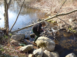
A volunteer monitor checks the water temperature
on the Millers River in Cumberland, RI.
Photo: Susan Thomas
|
2014 was the 11th season for the program, which encompasses 75 sites
from Worcester to Pawtucket. A fabulous crew of over 75 dedicated
volunteers monitor these sites along the Blackstone River and its
tributaries on the second Saturday of the month from April through
November. This long-term monitoring program provides critical data
on the status and trends of the quality of the Blackstone River watershed.
Anyone interested in the quality of the Blackstone River and its
watershed should plan to attend. If you've ever thought of becoming
a volunteer monitor, the Annual Summit is the place to begin! Please
R.S.V.P. to Susan Thomas,
acadia94@verizon.net
or 508-839-9488.
top
|
National Historic Park Status!
Supporters of the Blackstone River celebrated
December 19, 2014 when the Blackstone River Valley National Historical
Park was officially designated. Simultaneously, the J.H.C. Blackstone
River Valley National Heritage Corridor, designated in 1986 to connect
24 communities from Worcester to Providence, received an additional six
years of authorization along with the inclusion of Auburn and parts of
Providence to encompass the entire watershed!
This long-awaited legislation will help to support the preservation,
restoration, and protection of the industrial, cultural, and natural
heritage of the Blackstone River, canal, and associated communities.
The Park will include, among other sites, historic sites in Northbridge
and Hopedale as well as the Blackstone River, its tributaries, and the
canal.
top
|
Wildlands Map Viewer
The MA Department of Fish and Game recently
announced its online map system for state wildlife lands, which include
Wildlife Managment Areas (WMA) that are open to the public for multiple
sporting and recreation uses. Go to the main site at
http://maps.env.state.ma.us/dfg/wildlands/
and either type in a town or property name to pull up a map and fact
sheet. For example, you can access information on Lakey Pond WMA in
Northbridge, Quisset WMA in Blackstone, or Merrill Pond WMA in Sutton.
This is a great tool for exploring more of the Blackstone River watershed!
top
|
Switch to Green Electricity
Mass Audubon and Mass Energy have teamed up to
help the public switch to a more affordable, more sustainable form of
energy. Mass Energy "greens" the power grid that you already purchase
from with local wind, solar, and low-impact hydro electricity. You can
even deduct the money you spend through this program on your federal
tax return. Learn more and sign up at
http://www.massaudubon.org/get-involved/live-sustainably/at-home/make-the-switch-to-green-electricity.
top
|
|
FAMILY FOCUS
|
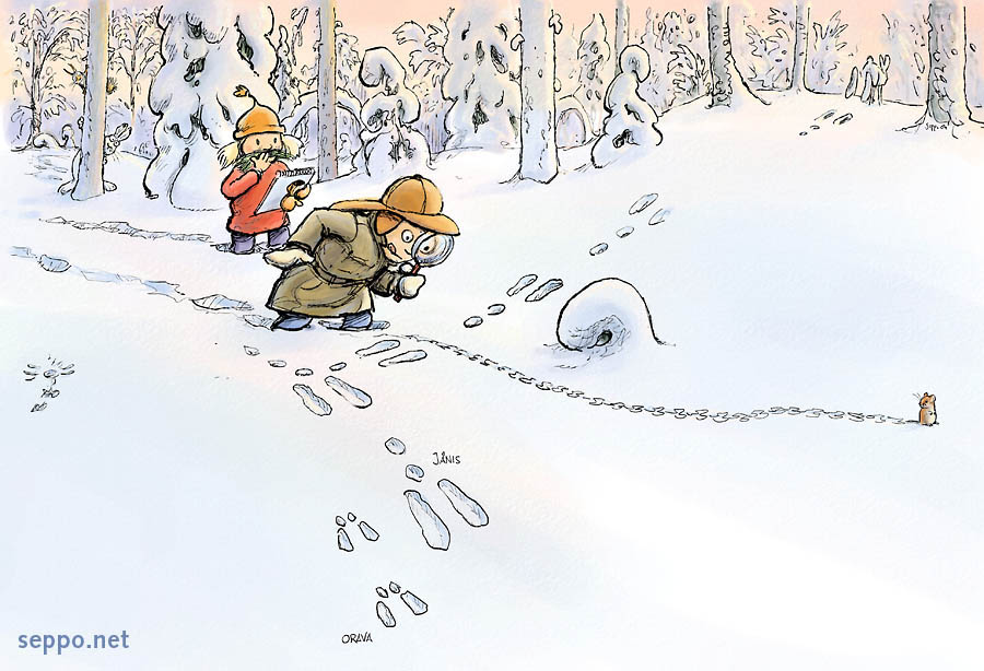
Tracking Big Foot....or little feet
One of the great joys of winter is how a thick blanket
of fresh snow can reveal the otherwise-secret goings on of critters in the
wild. One day you look out on a bare field or an empty stream and you wonder
if anything stuck around for the cold season. Overnight, a snow falls and
you wake up to the sight of animal tracks crisscrossing all over the place
like Times Square on New Years Eve! Time to grab a track guide and head out
to be a nature detective!
Sometimes you'll find a solitary print, but other times you'll discover a
series of prints called a track. The first thing to do is to identify which
of four basic track patterns you have. What follows is a simplified
description to start you off.
- Perfect Walker: If you see a single
line of prints with left and right feet alternating, it was left by a
canid (domestic dog, coyote, fox), felid (domestic cat, bobcat), or
deer. These animals place their hind foot in the track of their front
foot, so you'll only see the hind prints. Once you think you have a
perfect walker, you can sort out deer, which have two toes, from cats
and dogs, which have four toes. Cats and dogs can be further separated
by the presence of claw marks: cats can retract their claws; dogs can't.
Domestic dogs, which can count on a home-cooked meal, track all around
the place in their playful exuberance. Wild canids, like fox and
coyotes, leave straight paths as they search intently for their next
meal.
- Waddler: If you come across two
lines of prints, one left and one right, set fairly wide apart, it was
left by a heavy-set, low-to-the ground animal such as a bear, beaver,
porcupine, raccoon, opossum, muskrat, skunk, or woodchuck. You'll
notice that the larger hind foot slightly overlaps the smaller front
foot. There are several unique species differences that will help you
pinpoint a waddler's identity: porcupines are pigeon-toed; the hind
feet of raccoons have long toes that resemble human hands; opossums
have an opposable digit that sticks out to the side; and beavers have
webbed feet.
- Bounder: If your mystery track
pattern consists of single sets of side-by-side left and right paw
prints (each with five toes), you are tracking a member of the mustelid
family such as a mink, fisher, weasel, or otter (the last of which has
webbed feet). These animals move in an elongated, spring-like manner
with front feet landing first and then lifting up as their hind feet
bound into the print left by their front feet. Track size can be used
to distinguish the different species.
- Galloper: If you spot sets of four
prints with the larger two positioned slightly in front of the smaller
set, you are on the trail of a rodent such as a squirrel, mouse, vole,
or shrew. Rabbits, which are lagomorphs and not rodents, leave this
pattern as well, but often put one front foot in front of the other so
as to leave a Y-shaped mark.
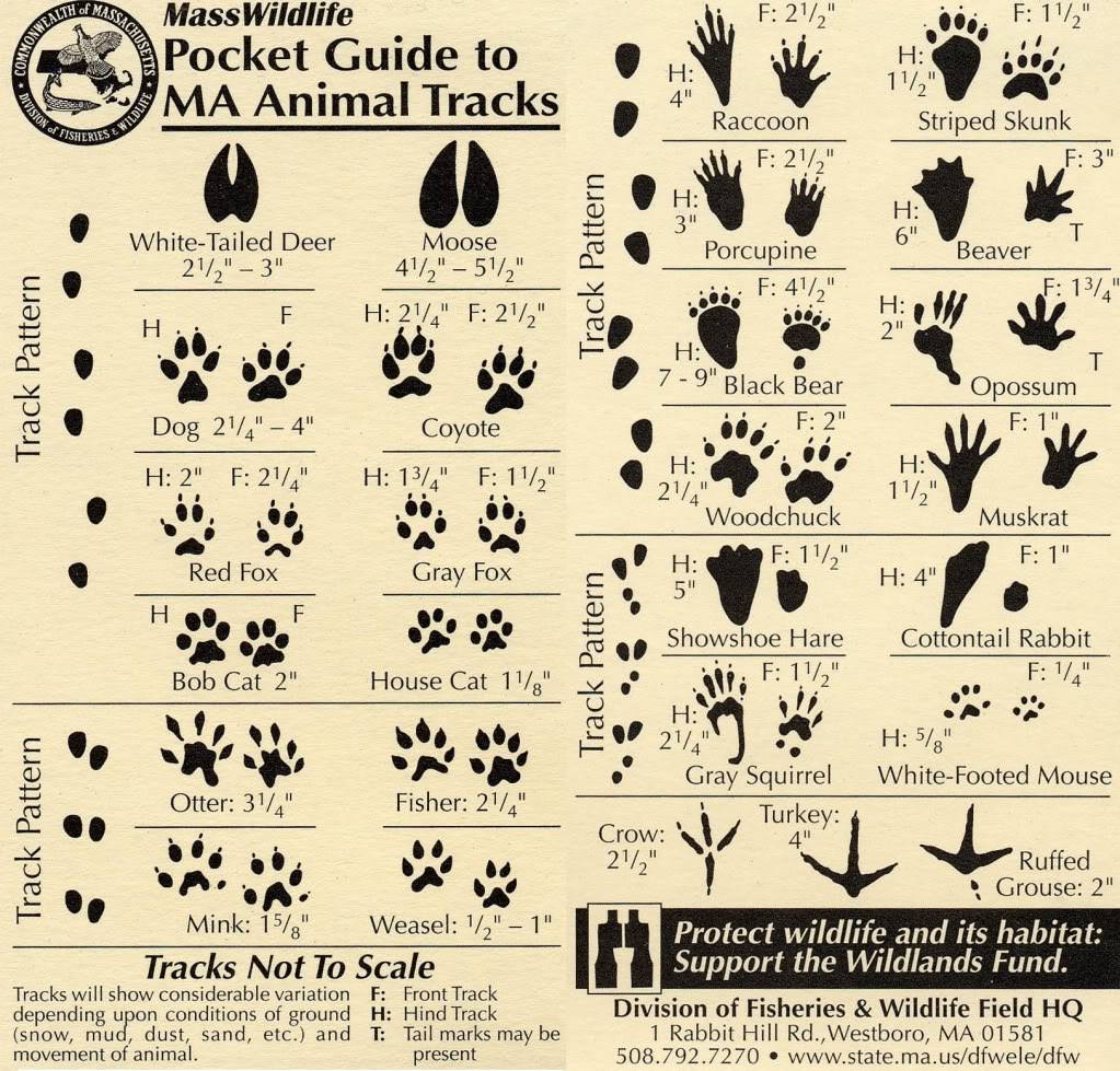
Many animals can be identified by the various dimensions of their tracks, so
you'll need a ruler if your track guide doesn't include one. You'll want to
measure the length and width of a single footprint, the distance between the
right and left side prints (called the straddle), and the distance between
the front and hind feet (called the stride). Math in action!
Keep in mind that as the sun warms and melts the snow, the prints will spread
out, leaving a misleading size. What you think was left by a bear may, in
fact, be an old, melted print left by an opossum! And don't be fooled by
chunks of snow that drop from tree branches and power lines, leaving behind
false imprints. Mother Nature can trick even expert trackers!
Regardless of the track size and pattern, habitat clues will go a long way to
helping you solve the mystery of "who done it". If you don't know which
bounder you have, remember that otter and mink are both found near water like
streams and wetlands. Another species that crosses streams back and forth is
a raccoon as it searches for crayfish and other food. Squirrels tend to move
on the ground from tree to tree for protection, with grey squirrels
preferring deciduous woodland and red squirrels preferring stands of conifers.
Mice and voles may alternate between being above ground looking for grass
seeds and below ground where it's easier to avoid predators like hawks and
owls. That's what happened if you are following a set of tiny prints in a
field and they vanish next to a small hole, only to reappear next to another
hole ten feet away.
As a nature detective, your job is to gather all the clues left behind and
come up with your best guess! Good luck!
Suggested References:
- Tracking and the Art of Seeing: How to Read
Animal Tracks and Sign by Paul Rezendez
- Mammal Tracks & Sign: A Guide to North
American Species by Mark Elbroch
- A Field Guide to Animal Tracks
(Peterson Field Guides) by Olaus J. Maurie and Roger Tory Peterson
- Mammal Tracks and Scat by Lynn Levine
and Martha Mitchell (life size and waterproof)
- Mass Wildlife Pocket Guide to MA Animal
Tracks
http://www.mass.gov/eea/docs/dfg/dfw/wildlife/wildlife-facts-pubs/tracks-guide.pdf
top
|
|
BE GREEN
|
 A New Years Diet for your Computer
Whether you work in an office or telecommute
from home, chances are you use a variety of electronic devices and
systems to manage your information/data.
 Did you know that storing your data in a cloud service uses less
renewable resources than using a local-based storage system? Did you
know you can shop for laptops and other devices based on ENERGY STAR
ratings, just like you do for your household appliances?
Do you already know to reduce your energy usage
by powering down computers and associated devices when they are not in
use? Do you know how to get more life out of your electronics by
passing them on when you are looking to upgrade, rather than throwing
them away? Public schools are one of many institutions that can find
a home for your old phone or printer. If you are unsure where to
donate an electronic, contact your town recycling office.
Did you know that storing your data in a cloud service uses less
renewable resources than using a local-based storage system? Did you
know you can shop for laptops and other devices based on ENERGY STAR
ratings, just like you do for your household appliances?
Do you already know to reduce your energy usage
by powering down computers and associated devices when they are not in
use? Do you know how to get more life out of your electronics by
passing them on when you are looking to upgrade, rather than throwing
them away? Public schools are one of many institutions that can find
a home for your old phone or printer. If you are unsure where to
donate an electronic, contact your town recycling office.
For more ideas on how to slim down your energy usage in 2015, go to
EarthShare.org.
top
|
|
REFLECTIONS
|
It is not half so important to know as to feel. Rachel Carson
The Frozen River by Alexis de Leeuw.
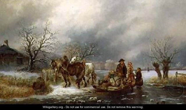
|
The Blackstone River is famous for its "hardest working river in
America" label dating from the American Industrial Revolution; we all
know how the river was used and abused for profit. As environmental
stewards, we strive to restore and protect the ecological integrity of
the watershed for the sake of flora and fauna. This painting by Alexis
de Leeuw reminds us that not all historic use of rivers negatively
impacted them. In this case, once frozen solid, a river could enable
transportation of goods and people.
top
|
Views & opinions expressed in linked websites do not necessarily
state or reflect those of the BRWA.
|
|
Your input is crucial to this eNewsletter. If you have a local
watershed-related story, information of interest to our subscribers, or
comments about this publication, drop an email to the editor.
The Blackstone River Watershed Association (BRWA) has a mission to
engage, educate, and advocate for improved water quality in the Blackstone
River Watershed; its objectives are to:
- Engage the public in watershed stewardship activities,
- Educate members, supporters, and residents on watershed protection strategies, and
- Advocate to local residents, community leaders, non-profit partners, and
state regulators to take actions that will help to ensure our waterways continue
to provide healthy habitat and enjoyable recreational opportunities.
The BRWA eNewsletter is published monthly by the Blackstone River Watershed
Association. BRWA is a 501(c)(3) non-profit organization.
Editor: Susan Thomas susan.thomas@thebrwa.org
Mailing address: BRWA, 271 Oak Street Uxbridge, MA 01569
Phone: 508-278-5200 Web: www.thebrwa.org
Click here for back issues.
|
|