
What is a Watershed?
Each body of water, including ponds, lakes, streams, rivers, and oceans, has its own, unique watershed. That is what we call the land over which rain and snowmelt travel via surface runoff or ground water infiltration prior to entering the water body. Since water always seeks the lowest level, ridges or high points on the land divide one watershed from the next so that rain falling on one side of the high point will flow into one watershed, whereas rain falling on the other side of the high point will become part of the adjacent watershed. Some watersheds are immense, like that of the Mississippi River, which drains parts of 10 states and measures over one million square miles. Other watersheds are more modest, like the 640 square mile basin of the Blackstone River, which receives water from 29 towns in central Massachusetts and Rhode Island.
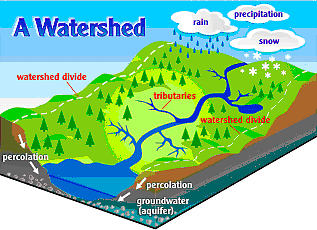
Diagram of a watershed from the Sandusky River Watershed Coalition.
Land use varies within a watershed, and may include farms, industrial plants, roads and highways, residential neighborhoods, wastewater treatment plants, golf courses, commercial developments, logging operations, and park lands. These activities have the potential to release pollutants into the environment, including heavy metals, hazardous chemicals, and excess nutrients. Some of these releases occur at a discrete location like a factory discharge pipe—these are called point sources of pollution. Other, more indistinct but cumulative releases are called non-point sources and include lawns that contribute fertilizers and construction sites that contribute sediment. It is important to understand that wherever you are, you are in a watershed and whatever you do on the land will affect the quality of the associated water body.